| This paged has moved. You will be redirected to the new page
automatically in 3 seconds. Please bookmark the correct new page at www.countrysideinfo.co.uk
|
ECOLOGICAL SAMPLING METHODS cont'd
Contents
| Belt
Transect Method This is similar to the line transect method but gives information on abundance as well as presence, or absence of species. It may be considered as a widening of the line transect to form a continuous belt, or series of quadrats. In this method, the transect line is laid out across the area to be surveyed and a quadrat is placed on the first marked point on the line. The plants and/or animals inside the quadrat are then identified and their abundance estimated. Animals can be counted (if they will sit still!), or collected, while it is usual to estimate the percentage cover of plant species. Cover is the area of the quadrat occupied by the above-ground parts of a species when viewed from above. The canopies of the plants inside the quadrat will often overlap each other, so the total percentage cover of plants in a single quadrat will frequently add up to more than 100%. Quadrats are sampled all the way down the transect line, at each marked point on the line, or at some other predetermined interval (or even randomly) if time is short. It is important that the same person should do the estimations of cover in each quadrat, because the estimation is likely to vary from person to person. If different people estimate percentage cover in different quadrats, then an element of personal variation is introduced which will lead to less accurate results. The height of plants in the quadrat can be recorded and the biomass of plants can also be measured by harvesting all the plants inside the quadrat and then weighing either fresh, or dry weight in the laboratory. This is obviously a very destructive method of sampling which could not be used too often in the same place. Sampling should always be as least destructive as possible and you should try not to trample an area too much when carrying out your survey.. An example of the type of results that can be obtained from a belt transect survey is shown below. |
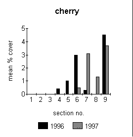 |
This figure illustrates the distribution and abundance of cherry seedlings along a transect line. The parent cherry trees were adjacent to section number 9. The gradient of distribution apparent in the figure is a result of the dispersal of seeds outwards from this point. |
| . For more illustrations of belt transect data, visit the wetland survey pages. Click here
Stratified sampling is used to take into account different areas (or strata) which are identified within the main body of a habitat. These strata are sampled separately from the main part of the habitat. The name 'stratified sampling' comes from the term 'strata' (plural) or stratum (singular). For ease of understanding, the term 'unit' will be used in the following explanation, rather than stratum. Individual habitats are rarely uniform throughout their extent. There are often smaller identifiable areas within a habitat which are substantially different from the main part of the habitat. For example, scrub patches within a heathland area, or areas of bracken in a grassland. One of the problems with random sampling is that random samples may not cover all areas of a habitat equally. To continue with the example of bracken patches in a grassland, if the area was random sampled, it is possible that none of the samples might fall within the bracken patches. The results would then not show any bracken in the habitat. Clearly this would not be an accurate reflection of the habitat. In this sort of situation, stratified random sampling would be used to avoid missing out on important areas of the habitat. This simply means identifying the bracken as a different unit within the habitat and then sampling it separately from the main part of the habitat. While the bracken area clearly needs to be taken into account, it is nevertheless important to avoid overemphasising its significance within the habitat as a whole. Its importance is kept in context by locating a proportional number of samples directly within the bracken unit. The proportion of samples taken within the unit is determined by the area of the unit in relation to the overall area of the habitat. For example, say the grassland area is 200 m2 overall, with the bracken patch occupying 50 m2 of this total area. The bracken therefore accounts for 25% of the total grassland area. Say it has been decided that a total of 12 samples need to be taken in order to accurately reflect the composition of the whole habitat. Then 3 of those samples (one quarter, or 25%) would be located within the bracken unit and 9 (three quarters, or 75%) in the general grassland area. There is a standard formula for calculating the number of samples to be placed in each unit. This is:
For example, in the illustration given above this would be:
|


Sample of raw data and extracted summary of raw data. |
Continue to sampling methods used on a Heathland Restoration site
Continue to sampling methods
used on a Woodland Restoration site
Continue to sampling methods used on a Wetland Restoration site
Ecological Sampling
Contents