The Woodland Education Centre
Heathland Restoration Project
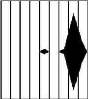
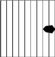
Distribution of the major grass species on the Project site
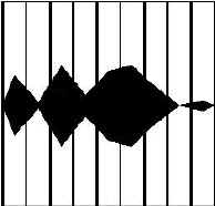
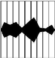
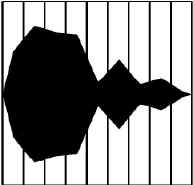
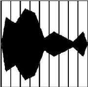
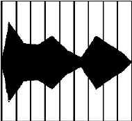
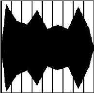
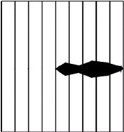
The kite diagrams below are a visual representation of the distribution of Yorkshire Fog (Holcus lanatus) and Agrostis spp. across the different sections of the project site (1-9).
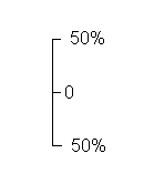
The distribution patterns shown are derived from mean % cover data from the belt transect surveys. The scale is shown below diagram A.
Each row represents the change in distribution of the named species with time (1996-1998).
1996 |
1997 |
1998 |
||||||||||||||||||||||||
A Yorkshire Fog |
B Yorkshire Fog |
C Yorkshire Fog |
||||||||||||||||||||||||
1 |
2 |
3 |
4 |
5 |
6 |
7 |
8 |
9 |
1 |
2 |
3 |
4 |
5 |
6 |
7 |
8 |
9 |
1 |
2 |
3 |
4 |
5 |
6 |
7 |
8 |
9 |
|---|---|---|---|---|---|---|---|---|---|---|---|---|---|---|---|---|---|---|---|---|---|---|---|---|---|---|
 |
 |
 |
||||||||||||||||||||||||
Scale |
D Agrostis capillaris |
E Agrostis capillaris |
||||||||||||||||||||||||
|
 |
 |
||||||||||||||||||||||||
F Agrostis spp. |
G Agrostis curtisii |
H Agrostis curtisii |
||||||||||||||||||||||||
 |
 |
 |
||||||||||||||||||||||||
I Agrostis stolonifera |
J Agrostis stolonifera |
|||||||||||||||||||||||||
Above: There is only one diagram for all the Agrostis spp. in 1996, because the species were not seperately identified in 1996. |
 |
 |
||||||||||||||||||||||||
| Heathland Restoration Project Report | ||||
Other Lowland
Heaths in East Devon