| This paged has moved. You will be redirected to the new page
automatically in 3 seconds. Please bookmark the correct new page at www.countrysideinfo.co.uk
|
The Woodland Education Centre
Heathland Project Report - Summary
Summary points 1-10 11-16 17-18 19-26
 |
left:
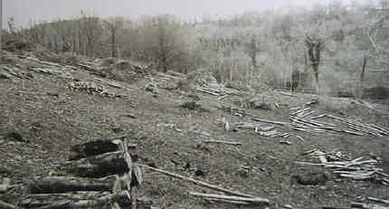
This former area of dense rhododendron and conifer woodland was cleared to start work on
restoring it as a heathland habitat. This is the site of the Heathland Restoration Project described in this report. |
The Heathland Project is concerned with restoring an area of former heathland in the Woodland Education Centre in Offwell, Devon, from conifer and Rhododendron woodland. Different management techniques are being used to identify which is the most appropriate
.Click on 'More Information' next to a summary point to go through to a more detailed discussion, which may include pictures, tables and charts.
| 1. The Woodland Education Centre is a Forestry Commission site, created and managed by the Offwell Woodland & Wildlife Trust. It covers an area of 50 acres. Over the last 12 years, the Centre has been restored from a virtually worthless Rhododendron jungle to an area of great ecological significance. A wide variety of different native habitats have been restored. More Information |
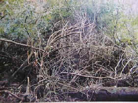
Rhododendron on the project site. |
2. The site selected for heathland regeneration covers an area of just over 2 hectares on the western boundary of the Centre. It is bounded by woodland to the north, south and west. On the eastern boundary is a cutting and path through the Education Centre, with coniferous woodland beyond (map). It lies at an altitude of approximately 200 metres.
3. The heathland project site comprises a hillside sloping down from west to east. It has been divided into nine approximately rectangular sections, with their long axes stretching from west to east (diagram). The sections are not physically separated from each other in any way, but are marked out with wooden boundary markers at appropriate points.
4. The soil substrate is composed of a thin top-soil, overlying greensand, which in some areas is completely exposed and lacking in top-soil. Soil pH varies from 4 - 5 across the site. More Information.
5. The original vegetation cover on the project site consisted of conifers and broad-leaved trees such as Sweet Chestnut, with an understory of Rhododendron. This was completely cleared in 1993. (This work was funded by the Countryside Commission.)
| Clearance resulted in an explosion of growth from seed banks previously dormant in the soil. (This would have resulted in only partial depletion of the seed bank, many dormant seeds would still have remained.) The initial regrowth consisted mainly of woodland species which would compete with regenerating heathland vegetation. It was therefore cleared by spraying with Roundup, which is a general purpose herbicide. This rendered the entire project site bare of vegetation, so that initially the site was superficially uniform. | 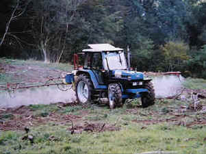 |
With these limitations in mind, different management regimes were assigned to each section with the aim of successfully promoting heather growth in one or more sections. To compensate for their small size (diagram) and the influence of the woodland boundary, sections 1 and 3 are duplicates of the same management regime, as are sections 2 and 4.
7. Management Details.| Action>> | Spring Brushcut | Summer Brushcut | Autumn Brushcut | Roundup Herbicide | Garlon & Kerb | Handweed | Initiated |
| Section No. | - | - | - | - | - | - | - |
1 |
- | - | + |
- | - | - | 1995 |
2 |
+ |
- | - | - | - | - | 1995 |
3 |
- | - | + |
- | - | - | 1995 |
4 |
+ |
- | - | - | - | - | 1995 |
5 |
- | - | - | - | - | - | 1995 |
6 |
+ |
+ |
+ |
- | - | - | 1996 |
7 |
+ |
- | - | - | + |
- | 1996 |
8 |
- | - | + |
+ |
- | - | 1996 |
9 |
- | - | - | + |
- | + |
1996 |
Summary of management methods
8. Methods. The vegetation on the heathland site has been surveyed annually in July for the period 1996 - 1998. The 1996 survey acted as a base-line survey of vegetation initially regenerating on the site (after the two prior clearances in 1993 and 1994). The site was surveyed by carrying out a belt transect across the centre of the site, encompassing all sections from 1 through to 9. Additionally, in 1997 and 1998, random samples were taken within each section. Sampling yielded data on the species present, their abundance ( % cover ) and maximum height. (Sample of raw data and extracted summary of raw data). This allowed comparisons to be made between the vegetation in sections under different management regimes, as well as showing overall changes in the site vegetation with time. More Information. 9. Two different methods have been used to survey the site. A belt transect was carried out every year from 1996 to 1998. Random quadrats were also sampled in 1997 and 1998. The results obtained using the two different methods were in many cases quite different from each other. This illustrates the need to use the same method of sampling when comparing results from different areas or over time. The random quadrat data was judged to be the most accurate. The two sets of data taken together provide a good picture of vegetation on the site. More Information. 10. A total of 90 species have been recorded on the project site over the period 1996 - 1998 (Species List). Most of these species are rare on the site. More Information. Continue to points 11-16| Heathland Restoration Project Report | ||||
Other Lowland Heaths in East Devon