Offwell Woodland & Wildlife Trust

Promoting the British Countryside

Home

About us Conservation Education Wildlife Habitats Maps Search Resources Sponsors


Offwell Wetland Survey
List of Diagrams, Charts and Tables
 

wpe6A.jpg (59266 bytes)

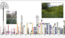
Line Transect Diagrams
These illustrate the changes in vegetation along the lines.

Continuous line transect diagrams depicting symbols of each plant species to touch the line along its entire length, together with water depth data.

Interrupted line transect diagrams showing plants touching the line every metre.

Interrupted line transect diagrams showing plants touching the line every other metre.

wpe83.jpg (1594 bytes)

Key for Line Transect Diagrams

Key to the Species shown on the Line Transect Diagrams.

wpe76.jpg (57139 bytes)

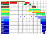
Plant Zonation Diagrams

Illustrate the range of different species in relation to water level.

wpe7B.jpg (34764 bytes)

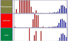
Species Distribution Bar Charts

Bar Charts indicating the relationship between individual species distribution and water level. 

wpe13.jpg (5803 bytes)

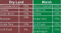
Dominant Species Table

Table showing the six most dominant species in the Wetland

wpe63.jpg (26553 bytes)

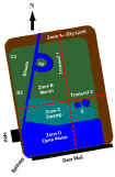
Diagram of The Wetland

A diagram of the Wetlands showing the transects and key areas

fwebsm.jpg (4573 bytes)

A Wetland Foodweb with notes


Wetland Survey Contents


Copyright © Offwell Woodland & Wildlife Trust 1998/9 & 2000/1/2/3/4 http://www.offwell.info

All the information including images, charts, movies and sounds is provided copyright free, only for educational use by: schools, colleges and universities unless you are making a charge. If you wish to use information or any part of this site for commercial purposes or for any purpose where a charge is made then you must get permission, so make sure you contact us first. Remember, if you are not a school, college or university you must obtain permission to use any part of this website. Note that company logos are reproduced with permission and remain copyright of their respective owners.